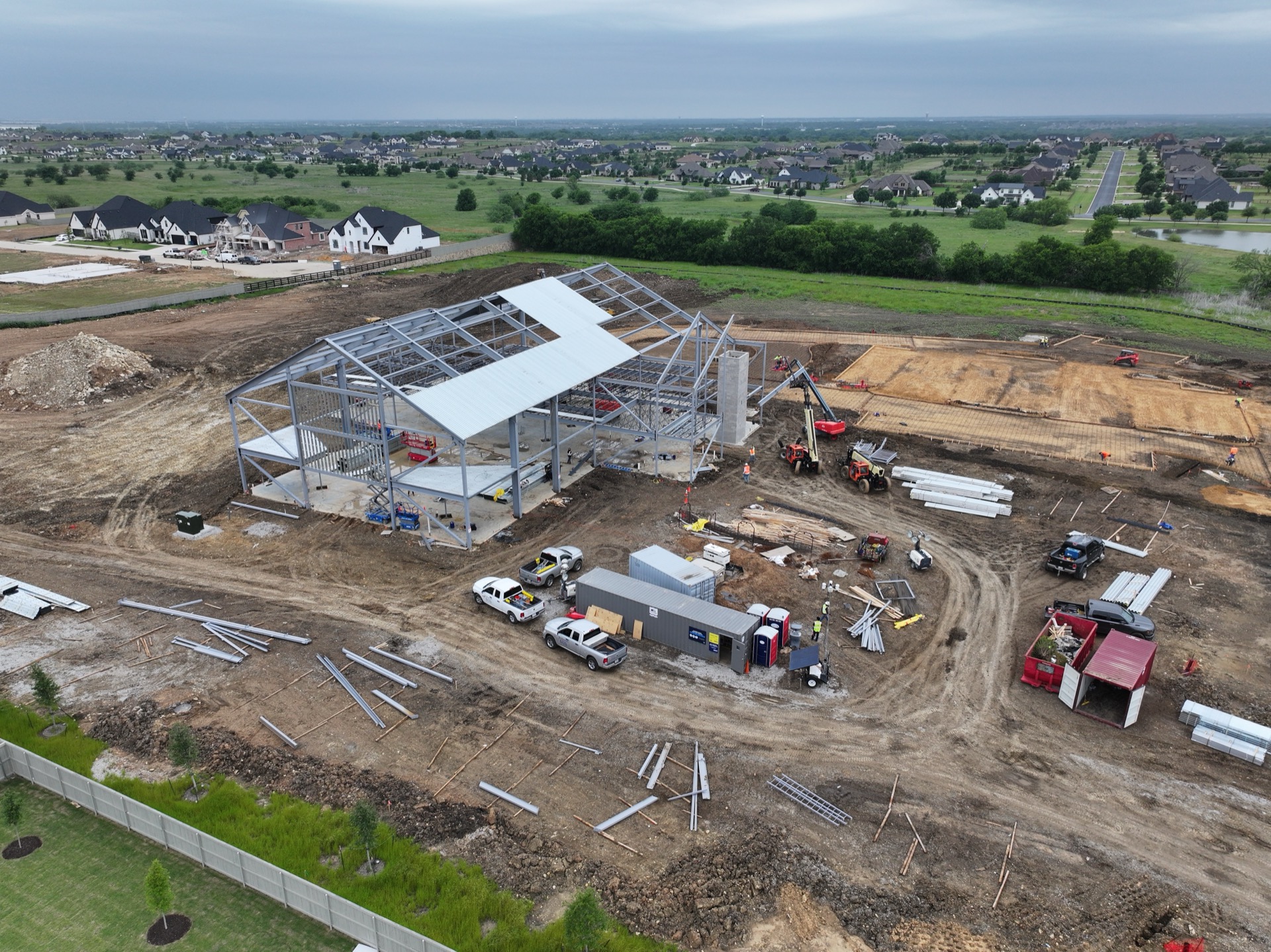
Aerial drone reality capture of a Texas construction site

    Construction Reality Capture

    Every Phase of Your Build Documented in One Place

    Aerial maps, 360° walkthroughs, and progress media that capture quality data of your whole site much better than phone photos, all viewable in one dashboard.

    For general contractors, home builders & developers across DFW & Central Texas

    What Reality Capture Delivers

    12%

    fewer rework hours

    when field teams document against one shared model instead of scattered texts and email

    Source: McKinsey
    75%

    faster project reporting

    when project documentation lives on one platform instead of scattered tools, with document hand-offs 90% faster

    Source: McKinsey
    53%

    of data-driven contractors finish at or under budget

    alongside 47% reporting higher productivity and 46% higher profitability

    Source: Dodge Data & Analytics

    What Is Reality Capture?

    Reality capture is a complete, time-stamped visual record of your jobsite. Three layers that together show exactly what your project looked like on any date, from any angle, all organized on your site map and floor plans.

    01

    Drone Photogrammetry

    High-resolution aerial maps and 3D models of your whole site, flown on the same paths every visit for clean, side-by-side progress comparisons.

    02

    360° Camera Walkthroughs

    Walk the interior from your desk. Every 360° capture is pinned to your floor plans, so you can pull up any two dates and compare them side by side, seamlessly.

    03

    Drone Progress Media

    Cinematic aerial photos, video, and progress time-lapses for owners, investors, and marketing, all from the same flights that document your build.

    See the Whole Site, Not a Pile of Photos

    Phone photos catch a corner here and there. Reality capture documents your entire site in high resolution.

    The Old Way

    • A blurry corner at a time, from wherever someone stood
    • Most of the site never gets captured
    • Low-res snapshots you can't zoom into

    The New Way

    • Your entire site in one high-resolution view
    • Every inch documented, not just the highlights
    • Zoom into any corner, on any date

    Reality Capture Across Every Phase

    From the first survey to final handover, every stage of your build is documented. Scroll through the phases or tap one to jump.

    See The Site Clearly Before You Mobilize

    Before anyone breaks ground, we fly the site and walk it with a 360 camera to build a complete visual baseline. You get accurate existing conditions for bidding, logistics, and early risk spotting, all geolocated on your site map.

    What You Get

    • Drone site maps and topography
    • 360° walkthroughs of existing conditions
    • Cut, fill, and stockpile measurements
    • Crane, access, and laydown planning visuals

    Why It Matters

    • Bid from real conditions, not guesses
    • Plan access, laydown, and haul paths
    • Align estimators, subs, and owners fast

    Pre-ConstructionSee The Site Clearly Before You Mobilize

    Before anyone breaks ground, we fly the site and walk it with a 360 camera to build a complete visual baseline. You get accurate existing conditions for bidding, logistics, and early risk spotting, all geolocated on your site map.

    What You Get

    • Drone site maps and topography
    • 360° walkthroughs of existing conditions
    • Cut, fill, and stockpile measurements
    • Crane, access, and laydown planning visuals

    Why It Matters

    • Bid from real conditions, not guesses
    • Plan access, laydown, and haul paths
    • Align estimators, subs, and owners fast

    SubstructureDocument What Gets Buried Before Backfill

    From earthwork through utilities and foundations, we capture every stage underground while it is still exposed. Aerial maps measure cut and fill, and 360 walks record trenches, piers, and embeds before they disappear.

    What You Get

    • Aerial cut and fill measurements
    • 360° captures of pre-pour and underground work
    • Grading plan overlays on live site maps
    • Geolocated proof for inspections and claims

    Why It Matters

    • Defensible quantities for material moved
    • Visual proof before cover-up
    • Fewer utility strikes and faster RFIs

    StructureTrack The Frame As It Goes Up

    As concrete and steel go vertical, we document each pour and erected bay against the plan. Repeatable flights and 360 walks give you clean side-by-side progress and a verifiable record of what was placed where.

    What You Get

    • Repeat flights timed to each pour or lift
    • 360° walks of in-slab sleeves, rebar, and embeds
    • Side-by-side comparisons from prior visits
    • Drawing and model overlays on the capture

    Why It Matters

    • Verify placement before the pour
    • Track steel and decking against schedule
    • Prove milestones to owners and lenders

    InteriorCapture The Walls Before They Close Up

    Once trades move inside, we walk the interior with a 360 camera to record framing, MEP, and above-ceiling work before drywall hides it. Every capture is pinned to your floor plans so any two dates compare side by side.

    What You Get

    • 360° interior walkthroughs pinned to floor plans
    • Above-ceiling captures of MEP and steel
    • A behind-the-wall record before finishes go up
    • Side-by-side room comparisons over time

    Why It Matters

    • Verify installs before inspection
    • Catch misses against as-builts early
    • Build documentation for facilities teams

    ExteriorInspect The Envelope Without The Lift

    We fly the facade on consistent paths as cladding, glazing, and finishes go on. High-resolution vertical imagery tracks percent complete and flags envelope issues from the air, with no scaffolding or boom lift required.

    What You Get

    • High-resolution facade and elevation imagery
    • Consistent angles for side-by-side comparison
    • Issue tags pinned to each elevation
    • Progress tracking by elevation over time

    Why It Matters

    • Track enclosure progress at a glance
    • Verify installation quality at milestones
    • Fewer ladders and lifts, lower risk

    CloseoutsHand Off A Complete Visual Record

    We close the project with final aerial imagery, a last 360 walkthrough, and a clean archive of every map, model, and capture from day one. It becomes your as-built reference for warranty, disputes, and facilities.

    What You Get

    • Final aerial maps and 360° walkthroughs
    • A full archive of every capture and map
    • Exportable files for your records
    • Owner-ready handoff visuals

    Why It Matters

    • A time-stamped as-built record
    • Support for warranty and disputes
    • One source of truth for facilities
    FAA Part 107 Licensed
    Fully Insured

    Proud Member

    Heart of Texas Builders Association Logo

    Recent Construction Projects

    Real footage from active sites across Central and North Texas. Tap a project to explore its full gallery.

    New to reality capture?

    Read the Reality Capture Playbook, Construction Edition, for a full breakdown of how drones and 360° cameras get used at every phase.

    Read the Guide

    What We Handle

    From the first phone call to the final link, we take care of the entire process. You just open the dashboard.

    Scheduling

    We coordinate every flight around your build timeline and the weather.

    Pre-Planning

    We map flight paths and capture points before we ever roll up to the site.

    FAA Compliance & Insurance

    Part 107 licensed and fully insured on every single job.

    Drone Data Capture

    Aerial imagery flown on consistent paths for clean comparisons each visit.

    360° Walkthrough Capture

    Ground-level 360° walks captured and pinned to your floor plans.

    Data Upload & Processing

    We upload, process, and stitch everything into maps and models.

    Platform Hosting & Portal Access

    Your project lives in one dashboard, hosted and managed by us.

    Final Delivery

    A clean, shareable link to your whole project, ready for the team.

    Construction Reality Capture FAQs

    Common questions from builders, GCs, and owners.

    What is reality capture in construction?

    Reality capture is a complete, time-stamped visual record of a construction site, built from drone imagery captured from above and 360° photo walkthroughs captured on the ground. Texas Drone Media organizes every capture on your site map and floor plans and updates it throughout the project, so the whole team can see exactly what the site looked like on any date, from any angle. Captures are delivered through a shared Google Drive folder, a custom per-visit landing page, or a full DroneDeploy dashboard depending on the plan.

    What's the difference between drone progress monitoring and reality capture?

    Drone progress monitoring delivers aerial photos and video of a site on a recurring schedule — great for tracking and marketing a build. Reality capture goes further: it combines that aerial imagery with 360° interior walkthroughs and organizes everything in one platform, pinned to your plans and searchable by date and location. With Texas Drone Media you can start with progress documentation (the Essentials plan) and step up to full reality capture (360° walkthroughs plus a DroneDeploy dashboard) whenever your project calls for it.

    Do I need to buy or learn any software?

    No. Texas Drone Media handles all of the capture, processing, and software. You receive a simple link — a Google Drive folder, a custom landing page for each visit, or a DroneDeploy dashboard — that you can open and share with your team, owners, and investors without any login or training. There is nothing to install and no platform fee on your end.

    What is DroneDeploy?

    DroneDeploy is the leading reality capture platform for construction. It brings drone maps, 3D models, and 360° walkthroughs together in one place, automatically organized on your site plans and timeline. Texas Drone Media captures your site and delivers it through DroneDeploy on the Reality Capture plan, so your whole project lives in a single all-in-one dashboard.

    How much does reality capture cost?

    Pricing is custom to each project — it depends on site size, which plan you choose (Essentials, Advanced, or Reality Capture), and how often you want the site captured. There are no set packages or hidden fees. Texas Drone Media offers a free demo on one of your active sites so you can see the deliverables before committing, then sends a custom quote based on your scope and cadence. Texas Drone Media is an FAA Part 107 licensed and fully insured owner-operator out of Waco, so quotes come straight from the pilot with no agency markup.

    See It on Your Own Site

    Book a free demo and we'll capture one of your active sites, no cost and no commitment, so you can see exactly what reality capture does for your project.

    Book a Free Demo Today

    Tell us about your site. We'll follow up within 24 hours to schedule a no-cost reality capture demo.

    Or call (940) 367-1185